
The Outrigger Horseshoe
- Jessie McAuley
- Aug 6, 2023
- 8 min read
Updated: Aug 27, 2023
This may be my first piece that actually follows suit with the name of my blog. On August 6th, 2023 Nick Elson and I rattled down the Squamish Main to explore a remote section of the South Coast. I learned about this mountain range that straddles the divide between Princess Louisa Inlet and Sims Creek in my teens. My fascination for this area has grown over the years. As of March 29, 2010, the name Mount John Clarke was officially adopted by the provincial government for the summit formerly and informally known as "Sun Peak. John Clarke (1945-2003) dedicated a great deal of his time exploring the ins and outs of the Coast Mountains. Clarke played a huge role along with conservationist and explorer Randy Stoltmann, and many others in helping to protect the Sims Creek Watershed, The Upper Elaho, and the Clendenning River Valley. These three valleys make up what Stoltmann and Clarke believed to be the largest tract of wilderness in the Southern Coast Mountains/Vancouver area. Void of humans, roads, and other distractions. Valleys with undisturbed primary forest and healthy grizzly bear populations are hard to come by within 150 kilometres of Vancouver.


In 2013 Nick Elson and Brad Schalles completed the Outrigger Horseshoe in 9 hours 58 minutes. The Outrigger Horseshoe entails ascending Outrigger Peak from the G mainline then following the ridge to a low col above Jarvis Inlet. From the low call the route turns back and follows the broad ridge line East to the summit of John Clarke. From the Summit of John Clarke it is one long descent to Sims creek via the Bug Lake Trail. Once back on the G mainline it is a nine kilometres back to the car. in total the route involves around 45 km and 3500 meters. Ten years later Nick was keen to re-explore this area but doing the traverse in the reverse direction ( John Clarke - Outrigger).
We parked our car at what is now the end of the G mainline. A washout destroyed the road at km 12.5 (from the Elaho mainline). It all worked out in the end since Nick and Brad had parked here previously. The Valley had changed dramatically since Nick's last time here. In June of 2015 a 650 Hectare wildfire torched the Elaho and the bottom of the Sims River Valley. As we commenced our 9 kilometer jog to the Bug Lake Trail I was shocked at how much timber the 2015 fire had damaged. The inferno burned everything in it's path from valley bottom to alpine. It wasn't long before I felt like we had moved into wilderness as the alder grew tighter and large bear scat littered the road every couple minutes. We passed the junction of Sims Creek and the Elaho River where we spotted several large grizzly and ungulate tracks on a sand bar. From here the G mainline turned into a bushwhack.


Nick and I moved along the G main for another 30 or so minutes before reaching the Bug Lake Trailhead. We missed the trailhead initially but backtracked a few hundred meters and found some flagging. Since the G main has fallen into such poor condition the Bug Lake Trail has become very faint and hard to follow. Within minutes we had already veered off route. We proceeded to thrash through steep coastal brush and followed the occasional game trail. We eventually found the Bug Lake trail again at around 1000 meters where the wildfire had burnt the upper section of the trail. We followed the rough trail for another couple hundred meters to Bug Lake.


Bug Lake is aptly named for the Bugs. We were lucky enough to stop for a couple bug free photos of the charming little lake before continuing up the 2000 meter climb to John Clarke.

Once we had reached the alpine, the heat and humidity started to take a toll on both of us. We were both out of water and becoming increasingly more heat exhausted. Finally with the glacier covered landscape of John Clarke we came across a water source. Nick and I both rehydrated and shoved some food in our mouths. With rainstorms building over the distant fjords the temperature dropped several degrees allowing us to get back into a nice rhythm without suffering from the heat. My mood lightened as we crested the ridge and were treated to spectacular views of the Coast Mountains.


After cruising up and down along the ridge we stumbled upon a set of grizzly tracks in the snow. A unique sight at 2000 meters elevation. The bear must have been looking for ripe berries on the south aspects of John Clarke.

Four and a half hours after leaving the car we reached the summit of John Clarke. I snapped a few photos, signed the summit register, and spent a couple minutes to taking it all in. It was nice to finally experience this summit. The landscape is impressive. Huge granite walls in every direction with glaciers wrapping around every summit.


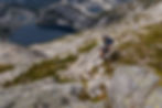
We descended the West ridge of John Clarke on 3rd class terrain to a col between the summit and a prominent sub summit. After a few moments of discussion we settled on bypassing the sub summit on some firm snow slopes. Once around the sub summit we continued West towards Princess Louisa Inlet. The ridge line is broad and covered in smooth granite slabs with stunning lakes in all directions. We ran down the ridge weaving back and fourth stopping for water and the occasional picture. It is a bonus to get some running miles in during a long day off trail.


From one point along the ridge as we approached Princess Louisa Inlet the PLI (Princess Louisa Inlet) Wall came into view. The PLI Wall is an impressive 1400 meter wall of granite directly above the inlet. Despite its size and ease of access there are only two routes that have been climbed on the PLI Wall. The PLI Trail (17 pitches, ED1/2 V 5.10+, Brodie-Rowat, 2002 and Journey to the Center of the Earth (25 pitches, VI 5.10+ C2, Besen-Heinrich, 2019. Neither party made it to the true summit of the PLI Wall which is likely still unclimbed. Though it is an incredibly impressive feature the low elevation poses some difficulties in the form of mosses, lichens, and all sorts of coastal munge. Here is a link to an AAJ article from the 2019 ascent.
The wall looked horribly uninviting from below—all we could see was moss and dirt—but the rock was actually quite solid and compact. Unfortunately, we were largely forced to avoid the cleanest stone, since our bolt kit had been seized by a ranger immediately upon arriving in Princess Louisa Marine Provincial Park. Instead, we stuck to the few continuous cracks we could find, which tended to be packed with dirt, mud, and flora. - Kevin Heinrich 2019

After a long section of pleasant cruising high above Princess Louisa Inlet we reached the low col at the back of the horseshoe. This meant we were roughly half way through the day in terms of distance with one third of the elevation gain still ahead of us. We sat down for a moment and ate some food before starting a long climb back to ridge that connects Outrigger and Mount Pearkes. The sky was growing increasingly dark and I had a feeling we might get rained on soon. In the meantime the cool temperatures felt great and a little rain might not hurt after all.


Once we reached the ridge we motored along. We were able to bypass several small sub summits along the way and cruise along the sun cupped snow instead. We reached the sub summit of Outrigger. This meant one more descent and one more long climb to the rounded summit. Nick and I were both happy about the tongue of snow that lay ahead of us. The descent down to the col went by fast as we ran and glissaded down the snow covered glacier. Once we were just above the col we down climbed a short section of low 5th class then a brief but unpleasant slope covered in loose rocks. This brought us the col below Outrigger Peak

From the Col we began our ascent to the summit of Outrigger Peak. With 3000 meters and around nine hours in the legs I was starting to feel it. We plodded upward primarily on snow taking a short break for water from a small stream. The impressive Slabs on the South face of John Clarke had just come into view. This 1000 meter granite face is likely unclimbed. It is not far from the car statistically but would still take a proper effort to reach the base. Something to think about for the future.

We were able to stay on snow and glacier for the majority of the ascent to Outrigger. Aside from wet feet, this allowed for fast travel. The broad glacier on Outrigger peak is littered in black pine needles and charcoaled debris. We attributed this to the 2015 Elaho wildfire. Tiny bits of debris could have been transported in plumes of smoke and deposited on the high glaciers.

As we approached the summit the rain finally started to come down on us. We were past any sections of slab where rain may have been an annoyance. I was slightly worried about this storm coming with thunder so we hastily tagged the summit, threw on rain jackets, pulled out the bear spray, and started plodding 2000 meters to the valley floor.


We were treated to some beautiful light as we cruised down summer snow fields.


The first third of the descent went smooth. Rambling alpine terrain intercepted with short talus fields. Once we encountered tree line the burn started to throw some challenges our way. Steep heather fields gave way to a dried up creek bed in an avalanche path. Once we could not see our feet we opted to thrash through the burn. Plenty of dead fall, head high Fireweed, and new deciduous growth made for some unpleasant slogging. We intercepted a few bear trails which made for slightly better travel. I thought that if I were to bump face to face with a grizzly now was the time. However, as we bumbled through the burn we made a lot of noise in the form of falling and breaking branches, likely spooking off any bears.


We still had another 500 meters to descend once we hit the logging road but the worst was likely behind us. Nick stopped to take some rocks out of his shoes before we starting running down the winding road. Bear scat littered the trail. I made sure to make some noise as we rounded each blind corner. The rain had subsided and the light was beautiful as we cruised down towards the truck. Right before the truck I stopped to wash off in a creek before ending the day.


Even though the day was filled with bugs, Sweat, and bushwhacks. The Outrigger Horseshoe was nothing short of spectacular. If I could think of one word to describe the group of mountains it would be wild. I feel fortunate to be able to access expanses of true wilderness not far from home. Sometimes the challenge to reach an area such as this has some allure. The heavy bush makes the endless granite slabs, alpine lakes, and spectacular glaciers feel like a real treat. I have a lot of gratitude for people like John Clarke and Randy Stoltmann for fighting to protect these wild spaces during a very important time in BC's logging and conservation history. If it was not for people like them the Clendenning, Upper Elaho, and Sims Creek would feel much different today.
Nick and I finished the day nearly an hour slower than when him and Brad completed this day in 2013. Neither of us are likely in worse shape than 2013. This is likely due to how much worse the access and exit from the alpine have become since the 2015 wildfire and landslides.
Outrigger Horseshoe
45 kilometres
3500 Meters
10:45:00
